In case anyone is interested, this started with a talk at the MathsJam Annual Gathering in 2022. This was then trumped by Ben Ashforth's visit to a street for every date in his 2023 talk[0].
I can't wait to see what someone does this year ... it's just four weeks away[1]. (But it is now sold out for in-person tickets ... remote attendance tickets still available.)
As a driver of large vehicles it would be nice if this was integrated into GOOG maps.
TomTom and other do a restricted roads SatNav, isn't it about tine GOOG did this?
My parents live on a tiny lane that narrows to the point where driving a car down it is tricky. Every few months a huge lorry will try to drive down it, get stuck and need help reversing back to the main road.
Every time this happens, the driver is using Google maps to navigate. Surely the cost of a decent satnav is nothing compared to running a lorry, let alone buying one.
Edit: Yes, Google maps adding support for restricted width/height roads would save a lot of trouble (assuming they haven't added it since I last checked)
Surely the cost of a decent satnav
Can you actually get a "decent satnav" (as in consistently better than Google Maps) any more?
There are route planners specifically intended for the transport business that do include such information.
"Lorry Route tailors all routes to your vehicles, ensuring you never hit a bridge, or get stuck down a road too narrow. Keep your vehicles, drivers and environment safe."
For instance: https://www.lorryroute.com/#benefits
I learned about this from Woolly Benguin's amazing talk at MathsJam last year in which he describes a road trip he took throughout Europe to visit streets named after each calendar day: https://www.youtube.com/watch?v=MwRbr-MjwII
As somebody who collects and manages a community-driven list of video games featuring Moai https://moai.games I can safely say that this is my jam. Nice work!
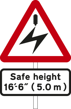
An additional height of 5.0m is possible on an overhead electric wire (railway/tramway) sign:
https://assets.publishing.service.gov.uk/media/5817085d40f0b...
https://www.alamy.com/stock-photo-a-railway-safety-sign-in-e...
It might interest HN readers that Donald Knuth (of The Art of Computer Programming fame, among others) enjoys taking photos of yellow, diamond-shaped road signs. He has quite a collection!
I think the lowest bridge near-ish me is near the station in Ely, 2.7m https://maps.app.goo.gl/aA4z4oBHVDGy8Lsx6
I would genuinely be amazed if there was anything at the 1m mark.
To be fair 1.3m is already ridiculous. Can any vehicle get through that? An oldschool Mini is taller.
I live near the 1.5m one, it's not really used by road vehicles (or at least I've never seen anyone try it), it's a path used by cyclists / pedestrians.
https://adamtownsend.com/heighthunt/height.php?height=1m5-5f...
Side note: as you might guess from the picture / measurement - this thing is extremely awkward to navigate, especially by bike.
A modern Mazda MX-5 Miata can apparently get through that at 1230mm or so, although a taller driver with the top open may have to duck. It's the first car that came to my mind when trying to think of one, so there may be other modern examples. That said, it's relatively famous for the latest-generation maintaining about the same size as the first-generation NA Miata in the 90s.
Looking at the tire marks on the photo (visible in Google Street View as well [0]), this tunnel seems to be in regular use.
I think 1.3m is the lowest point of the arch on the left and right rather than the middle of the arch, probably the arch would get up to 1.5 or so
I would imagine a bunch of sports cars can do this, a BMW M1 for example is going to fit, some versions of the McClaren F1. The original Ford GT40 is uh, 40 inches high.
Looking at the bridge with 1.3m clearance its an arch and I suspect the 1.3m applies to the sides not the middle of the arch?
A DeLorean could, with 9” to spare